San Francisco Peaks

San Francisco Peaks

Friday, April 15, 2016

What if...? A look at a potential eruption scenario in the SFVF

*Disclaimer: This IS NOT a real prediction of an eruption in Flagstaff!!!! This is a hypothetical situation to give you an idea of the hazards of volcanoes and to give me a chance to use my volcano monitoring knowledge.*

Hello everyone. This week I have a post that is a little closer to home...

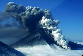
So, Flagstaff. Such a nice mountain city situated right in the midst of a potentially active volcanic field (SFVF). The most recent activity in the SFVF was the eruption of Sunset Crater less than a thousand years ago. The majority of the volcanic field consists of cinder cones.
The SFVF. Can you find Flagstaff?

Thus, what would happen if a cinder cone popped up and started spewing lava out near Sunset Crater?? (This post will detail the eruption. Next week will detail monitoring and safety precautions.)

Here is the a screenshot of the Sunset Crater area from Google Earth. Sunset Crater is in the rectangle. The circle will be where my eruption is going to occur. (I'm not actually saying this is going to happen. This is me just theorizing.)

We are facing North in this picture.
Zooming in. Keep yourself focused on the star to help orient you.


Yay! We know where we are now. And the volcano just started erupting!!!!!
So the eruption is set for today and I will be using the Ash3d website (https://vsc-ash.wr.usgs.gov/user/session.php) to model my fake eruption. Thank you to my adviser Dr. Greg Vaughan for allowing me to use his Ash3d account.

The volcano erupts for hmmm how about 24 hours. The ash plume height will be 9.447 km high and 0.003 km^3 material will be erupted (the default settings on Ash3d). Below I will have a gif showing where the ash plume will go and a picture showing where ash will be deposited over 48 hours.

The ash cloud seems to generally be headed south, then starts to curl northeast. It heads further south into Arizona before blowing over into New Mexico, Colorado, and Texas.
See the screenshots from Google Earth below to see where ash deposits might occur.
Deposit Thickness

Zoomed in version of above.
You can see that the ash deposits would remain in the state of Arizona. They will affect areas almost directly south of the Sunset Crater area. It would not reach Phoenix though. The ash deposit would be very light, so it won't be as noticeable as the deposits from the Mt. St. Helens eruption in the 1980s.

See you next week when we discuss hazards and affected areas!
Rachel

Monday, April 11, 2016

Takeaway from the Case Study Restaurant and other assorted thoughts


My thanks to this website for this gorgeous picture: http://www.georama.com/blog/fire-and-ice-volcanoes-of-iceland/

Welcome to the final stretch of this project. There is less than a month before I present my research... Wow.

This week I thought I would synthesize the lessons from my case studies and discuss some of the answers to questions I had that I received from Dr. Tina Neal.

I have discussed the eruptive styles, activity, and type of monitoring at the following four volcanoes: Mauna Loa and Kilauea, Hawaii, and Cleveland and Pavlof, Alaska. Each volcano has been active within the last 45 years. Each has its own "normal" behaviours. Each has the ability to erupt and affect thousands of people, whether that is destroying homes or grounding flights or somewhere in between. 

From my observations and research, the most widely used monitoring technique is the measurement of seismic activity. All the volcanoes I studied have some sort of seismic array that allows geologists to detect changes in the intensity and frequency of seismic activity. Usually (remember volcanoes are rebels- they don't always do what we expect), the seismicity increases in intensity and frequency before an eruption. This could happen minutes or months before the eruption. Sometimes one of the two (intensity and frequency) happens or the other. Despite the deviations from normality in volcano activity, the measurement of seismic activity seems to the best baseline form of monitoring.

I would say that the measurement of ground deformation is the next important monitoring technique. It provides geologists with an idea of the happenings within a volcano as magma moves in the subsurface. Depending on the volcano, inflation or deflation of the summit and flanks of the volcano precede eruptions. This technique seems to be used on volcanoes that are closer to people and observatories, but it is another key into unlocking the mysteries of volcanic eruptions.


Satellite monitoring is the up and coming technique. It is best for geologists in places like Alaska where many volcanoes are a great distance from the observatory. Satellite's infrared and thermal sensors are able to detect ash plumes and thermal anomalies sometimes before they are reported by pilots. Using computer models and simulations, geologists are able to predict where ash will be dispersed and thus, warn of ash deposits and clouds. This will also keep air traffic away and safe from ash clouds. Satellites provide constant coverage of all volcanoes around the world; however, there is not enough of them to always be photographing volcanoes. The expense is also high to put them into orbit and operation. Yet, Francis and Rothery (2000) believe that a satellite dedicated to volcanology is needed to meet requirements of aviation safety and volcano monitoring.

Other forms of monitoring I have mentioned are important, but do not make appearances in literature as much as the three discussed above. As part of my research I asked Dr. Christina Neal-the current Scientist-in-Charge (SIC) of HVO and was the previous SIC of AVO- some questions about monitoring.

My questions are bolded and her emailed responses are italicized. 

How many seismometers and seismic stations are needed to properly monitor an active volcano?
This is a very difficult question. In a perfect world, several dozen seismometers (and other kinds of monitoring instruments) would monitor every potentially volcano, but this is very expensive and likely never to happen.  You can do adequate monitoring to detect unrest and eruptions with as few as 6 if they are working consistently.  Some of our volcanoes have only 1!  It depends on how much lead time you wish to have - you cannot locate earthquakes with very small networks.  Largely, it is a decision based on economics and the trade off of time.  And, as other techniques like infra sound come to fruition, there will be other combinations of instrumentation used to monitor volcanoes.  
 

What are your opinions on satellite tools for monitoring?
This is a very important and growing technique – for detecting actual eruptions (lava, ash clouds) or in some cases the precursors (increased heating, gas output, ground deformation using Interferometric Satellite Radar or InSAR).  I foresee this becoming a larger part of Observatory operations in the future.  AVO and HVO are both leaders in developing alarm systems that utilize satellite data to inform scientists when activity may be occurring. 

I find it interesting how many sesimometers are actually needed to detect the tiny tremors within the earth. I only know of one seismic station within the SFVF and that is the one for Sunset Crater at Wupatki (see Sunset Crater a millennial). But this discussion on Flagstaff monitoring strategies will continue this week and next.


Pavlof
Pavlof
See ya,
Rachel

Sources:

Email correspondence with Dr. Neal in March 2016

Francis, Peter, and David Rothery. "Remote sensing of active volcanoes." Annual Review of Earth and Planetary Sciences 28, no. 1 (2000): 81-106.


Friday, April 1, 2016

I dump Mt. Redoubt and introduce Pavlof properly

*Please read "The resurrection of Pavlof" before continuing this post... It will make more sense.*

So this is an update on my project and a case study on Pavlof.

After meeting with my project advisor, Dr. Greg Vaughan, we have decided that I should do a case study on Pavlof volcano, not Mt. Redoubt. There are a few reasons for this...

   1. Pavlof volcano erupted this week and I was able to collect some data (satellite images) on the eruption.
   2. I was not that far into the Mt. Redoubt case study when Pavlof erupted, so I will not be wasting time switching volcanoes.
   3. Pavlof has been more active than Redoubt within the past ten years, so there will be more information for my case study.

I am excited about the change. So here is the case study of Pavlof volcano.

Case Study

Name: Pavlof
Location: Alaska
Type of Volcano: Stratavolcano, pyroclastic cone
Elevation: 2493 m (8177 ft)
Rock type: Andesite, Basalt
Hazards: Ash plumes and deposits, steam, gas emissions, lava flows, lava fountains, pyroclastic flows, earthquakes, lahars (mud slides caused by melted snow and ice)
Monitoring: Seismic stations, satellite, webcam, fly-by
Last Eruption: 2016

Current Status: Active
Current Activity: Elevated seismicity, possible low-level ash plume, obscured by clouds so hard to detect thermal anomalies

On Tuesday I posted many satellite images of Pavlof and its current activity. But I made a mistake in my last post... I said that the white spots are the thermal anomalies and the black are snow. Depending on the image, the temperature scale is different. So in some images the white spots ARE thermal anomalies and in others the black spots are thermal anomalies. Refer to the monochromatic bar at the bottom of the picture to figure out which color shows heat.

Remember the circle indicating the volcano is probably off!!

March 30, 2016


March 31, 2016


Notice how cloudy these images are... Compare them to the images in the previous post.

This happens when there is background noise and the satellite takes a picture.


 A few comments on the images. you will notice most of them are cloudy, thus making it difficult to pick out any white or black spots. That is what the Alaska Volcano Observatory (AVO) has described in their volcanic activity updates. You can see here some of the limitations of satellites. They provide good images of a large area, but the images can be obscured or messed up by clouds, the atmosphere, and background noise.

As Pavlof is the most active volcano of the Aleutian Arc, there is a plethora of eruption accounts. In my research of Pavlof, I have learned some things about this volcano. And today feels like a list day so here goes....

  • Ash and steam explosions seem to be a characteristic of this volcano, which pose threats to aviation whenever Pavlof erupts.
  • Lahars are often created when Pavlof erupts.
  • Satellites generally detect thermal anomalies at Pavlof before people report lava fountains. It also seems that satellites are heavily relied on to provide images of ash plumes and their direction.
  • The increase and decrease of seismic activity seems to be the best indicator of activity at Pavlof volcano. Because usually after an increase in seismicity, there is some sort of eruptive event. So for this volcano, seismic monitoring is crucial to detecting an eruption. 
That's all for now.
Rachel