Hope you are enjoying snow or sunshine. This post was supposed to be about Mt. Redoubt, but because of the sudden eruption of Pavlof volcano, I decided to discuss Redoubt later.
Pavlof is a strata volcano and pyroclastic cone. It stands 2493 m (8177 ft) high.It last erupted in 2014 when there were thermal anomalies and ash plumes; however, the eruption these last couple of days seems to have had little warning.
 |
| Here is Pavlof's location in the Aleutian arc. |
March 27, 2016
The seismicity picked up only about a half hour before the eruption. A pilot reported the eruption describing an ash cloud of 20,000 ft.
March 28, 2016
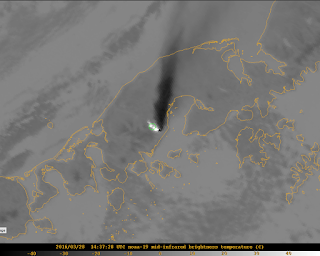
Eruption is continuing. The level of seismic tremor is high. Infrasound sensors have gathered data that the volcano is still erupting ash. The ash cloud is now 37,000 ft. Lava fountaining could be seen at night by residents 37 miles away (60 km). There is a warning about mud flows as Pavlof is covered in snow and ice.
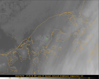
The green circle indicates Pavlof in the satellite images. It might be a little off, but you should be able to see the ash plume and the white and black spots revealing thermal anomalies.
March 29, 2016
There is no ash plume showing up on satellite data. Yet, the ash cloud could still affect aviation. Seismicity and infrasound levels have dropped, but the seismic tremor is greater than normal background seismicity. The AVO warns that even though the intensity of the eruption has decreased, the volcano is still capable of erupting with little warning (if any at all).
Here is the seismicity for the last 48 hours.
There were 41 flights canceled yesterday and 14 today. The National Weather Service issued an ash fall warning and the village, Nelson Lagoon has almost received an inch of ash accumulation.
This eruption is just a reminder of the unpredictable nature of volcanoes and the many hazards they pose. I did enjoy looking through the satellite images and realizing I could see the ash cloud. I hipe that I can find more data and information on this eruption as it is so recent.
If Pavlof or one of our other fiery friends wakes up more, I will be sure to report on it.
Rachel


Where exactly is this volcano located? I liked the summaries you provided at the top of your posts on the various other volcanos that included location, height, etc. Could you add that information to this post? Also, could you explain what a thermal anomaly is and why it creates the black and white spots seen in the images?
ReplyDeletePavlof is part of the chain of islands trailing off Alaska. I will provide a picture and more information above. Because this volcano was not originally one of my case study volcanoes, I didn't treat this post the same.
DeleteA thermal anomaly is when temperatures near the surface of the ground or the summit of the volcano rise above either "normal" behaviour or show up in satellite images. The black and white spots are from the infrared camera and show the temperature of the summit of the volcano. In the photos above the lighter (white) the color the higher the temperature in Celsius. This will be the magma giving off heat. And then the darker the spot (black) the colder the temperature so this is probably showing the ice and snow.
Great report! Thanks for the update.
ReplyDeleteHow common is it that volcanoes give such little warning, in our era of scientific observation? Also, when we do have warning, what steps do localities take to protect their people? Is this like with hurricanes where people are encouraged to vacate but not required to? Where does scientific observation meet policy making?
ReplyDeleteHonestly, even with all the technology we have, it is quite common for volcanoes to give no warning signs. While volcanoes usually give warning signs from hours to years in advance, they don't show any signs often enough that we will not always know what will happen next. As technology and our knowledge of the inner workings of volcanoes improve, hopefully this uncertainty will decrease.
DeleteFor your other questions, the answer is it depends. The safety precautions taken by communities depend on where they are, what type of volcano is erupting (or showing signs of activity), what kind of eruptions the volcano experiences, how far away it is, etc.
In Hawaii, for example residents are well-informed and aware of the hazards of living near volcanoes. They have put up levees to divert lava and there is a warning system in place like there are for hurricanes or forest fires.
I will try to address more of the policy making in my final paper and presentation in relation to Flagstaff and its lack of warning systems.